
Drones have revolutionised multiple industries, from filmmaking and photography to agriculture, real estate, and construction, bringing about changes that we could only dream of a few years ago. Commercial drones are soaring high in this new era of technological advancement, representing a game-changing tool for businesses worldwide. Their remarkable capabilities and versatile applications have set the stage for a drone-filled sky in the future. In this detailed blog post, we will take a deep dive into the world of commercial drones. We will be exploring the best commercial drones available in the market in 2023, their distinctive features, cutting-edge technology, and their prospective industry applications.
Whether you’re a seasoned drone operator looking to upgrade, a business exploring innovative ways to increase efficiency, or a tech enthusiast curious about the latest trends, this guide is just for you. Let’s embark on this exciting journey as we unveil the powerful and innovative commercial drones that are shaping our future.
As we venture into the world of commercial drones, it’s important to clearly understand what these devices are, their capabilities, and what they are used for.
What Is a Commercial Drone?
Commercial drones are distinguished by their purpose – they are designed and utilised for commercial, industrial, or business applications.
While consumer drones are often used for personal entertainment or hobbyist activities like amateur photography, commercial drones are equipped with more advanced features to cater to professional requirements. These include high-resolution cameras, thermal imaging, LIDAR technology, increased flight times, robust build for durability, superior flight control systems, and often a higher payload capacity to carry additional equipment.
Industries Where Commercial Drones Are Used
The practical uses of commercial drones span a multitude of industries, showcasing their versatility and the value they can add to various business operations.
Film and Photography: Commercial drones equipped with high-quality cameras have revolutionised this industry, making aerial photography and cinematography more accessible and affordable. They are used for shooting movies, advertisements, music videos, and even in news broadcasting.
Agriculture: Drones have proven to be a boon for farmers and agronomists. They help in crop monitoring, irrigation management, soil analysis, and pest detection, making farming more efficient and precise. The use of drones in agriculture is one of the fastest-growing in any industry and will revolutionise many farming methods.
Real Estate: Drones are used for capturing aerial photos and videos of properties, offering potential buyers a unique perspective and a more comprehensive view of their prospective purchases.
Construction and Infrastructure: Drones are increasingly used for surveying land, mapping construction sites, inspecting structures, and monitoring progress. They offer safer, quicker, and more accurate data collection than traditional methods.
Emergency Services: In firefighting, search and rescue, and disaster response, drones can reach areas humans can’t, making them an invaluable tool in emergency situations.
Delivery Services: Companies like Amazon, Walmart, and UPS are already providing drone deliveries, aiming to increase efficiency, lower operating costs and reduce the carbon footprint of their operations.
Environmental Monitoring and Conservation: Drones are used for wildlife tracking, forest monitoring, and in conservation efforts. They offer a non-intrusive method of collecting valuable data to support ecological research.
Oil, Gas, and Mining: Drones are used for inspecting pipelines, rigs, and mines, often in inaccessible or hazardous areas, thus reducing risks and increasing efficiency.
This is by no means an exhaustive list. Other sectors like telecommunications, insurance, and security also employ drones for various purposes. The common thread among all these applications is the ability of drones to provide a bird’s-eye view, collect valuable data, and perform tasks more efficiently, safely, and economically. As technology continues to evolve, we can only expect the list of industries benefiting from commercial drones to grow.
10 Best Commercial Drones
1. DJI Matrice 300 RTK
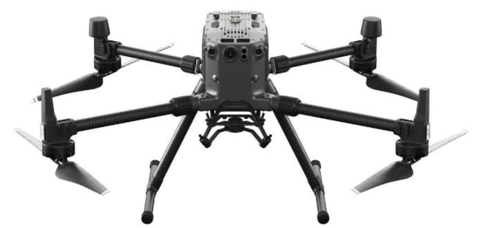
For Public Safety, Inspection, Mapping & Surveying.
The DJI Matrice 300 RTK is a professional-grade drone designed to be operated in all types of weather conditions. This commercial drone offers sophisticated technology for industrial, commercial, and public safety applications. Equipped with Real-Time Kinematic (RTK) modules, the drone provides highly precise position data, essential for professional use. The device includes six-directional obstacle avoidance sensors for comprehensive situational awareness, an impressive flight time of up to 55 minutes, a maximum payload capacity of 2.7 kg, and the capability to support three payloads simultaneously. Additionally, it features advanced AI functionalities for intelligent inspection and tracking and ensures secure data transmission with AES-256 encryption.
This drone finds use in a multitude of applications that require high-precision operations. It’s an invaluable tool in surveying and mapping, thanks to its advanced RTK system. Its long flight duration, improved payload capacity, and smart AI capabilities make it suitable for public safety and search and rescue missions. In inspection scenarios, like powerlines, wind turbines, and infrastructure examination, it’s capable of carrying various sensors and cameras. Furthermore, it benefits the agriculture industry by equipping multispectral sensors for crop health monitoring and the construction industry by aiding in site surveys and progress tracking.
2. DJI Matrice 30/30T
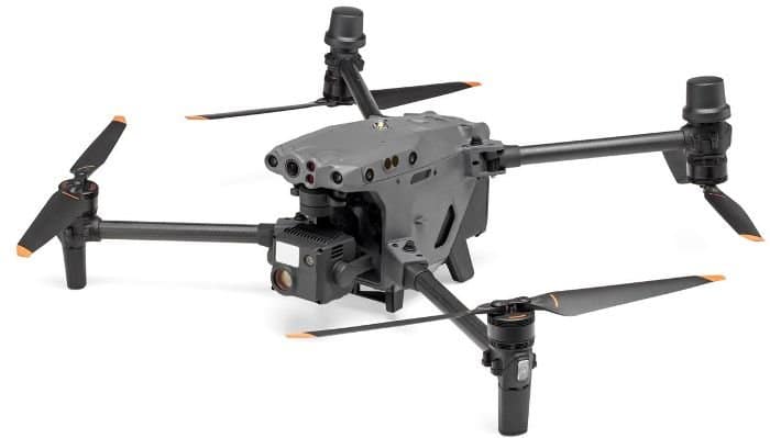
For – Public Safety, Security, Inspection
The DJI Matrice 30 Series is a revolution in commercial drone technology, boasting an incredible blend of robust, compact design, flight performance and adaptability to various environmental conditions. This series includes the M30 and M30T drones, both equipped with dual-vision and Time of Flight (ToF) sensors, enhancing safety during operations. The drones’ redundancy systems offer additional reliability, ensuring mission continuity in unpredictable circumstances.
These drones are outfitted with the OcuSync 3 Enterprise system, ensuring superior data transmission. Despite their advanced features, the drones retain a compact and portable design, facilitating easy transportation and deployment in the field. A key aspect of the M30 series is its advanced imaging system, featuring wide, zoom, and in the case of the M30T, thermal cameras, along with a laser rangefinder for comprehensive aerial data capture. The series also includes a night vision FPV camera, enhanced with starlight sensors, enabling exceptional performance in low-light conditions.
The DJI Matrice 30 series is compatible with the DJI Dock. DJI Docks are rugged and reliable docking stations for Matrice 30 drones, allowing them to land, recharge, and execute programmed missions.
They can be managed and controlled remotely through DJI FlightHub 2, offering mission scheduling, route planning, data management, and live streaming features. The docks support fast charging and are designed to withstand various weather conditions.
3. DJI Phantom 4 RTK
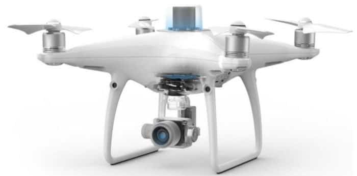
For – Mapping, Surveying & Agriculture
The DJI Phantom 4 RTK, a high-precision commercial drone, was designed primarily for professional and industrial uses such as mapping, surveying, and inspections. It has several advanced features that make it especially suitable for commercial applications.
At the core of the Phantom 4 RTK’s capabilities is its built-in Real-Time Kinematic (RTK) module. This provides real-time, centimetre-level positioning data for improved absolute accuracy on image metadata, making it an essential tool for precision commercial operations. The drone is equipped with a 1-inch 20MP CMOS sensor camera to capture high-quality images, ensuring detailed and clear photos essential for commercial use.
Its obstacle-sensing feature further enhances the Phantom 4 RTK. The drone can sense obstacles in five directions and boasts four directions of obstacle avoidance, making it safe for use in complex commercial environments.
The Phantom 4 RTK has a flight time of approximately 30 minutes and a top speed of 58 mph, making it efficient for commercial tasks. It uses OcuSync transmission technology, providing an operational range of up to 7 km and ensuring reliable HD image and video transmission.
The Phantom 4 RTK also features a TimeSync system that continually aligns the flight controller, camera, and RTK module data, ensuring each photo uses the most accurate metadata.
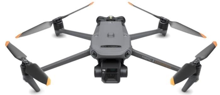
4. DJI Mavic 3M
For – Agriculture, Forestry management, Environmental monitoring
The DJI Mavic 3 Multispectral is a sophisticated commercial drone for precision agricultural, forestry and environmental management. Its dual imaging system, combining a 20MP RGB camera and four 5MP multispectral cameras, allows detailed aerial surveys and crop health monitoring. An embedded sunlight sensor and RTK module ensure accurate data collection and precise positioning.
This drone’s notable features include an exceptional 43-minute flight time and a 15km transmission range facilitated by the O3 transmission system. Its omnidirectional obstacle sensors enable a terrain-following aerial survey, ensuring smooth navigation in complex landscapes.
In practical applications, the DJI Mavic 3 Multispectral excels in orchard mapping, variable-rate crop applications, automatic field scouting, and environmental monitoring. By integrating with the DJI Terra or DJI SmartFarm Platform, it can produce vegetation index maps and prescription maps, resulting in cost-efficient and effective crop management. Beyond agriculture, it assists in natural resources surveys and urban green area monitoring, underscoring its versatility.
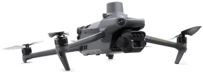
5. DJI Mavic 3 Enterprise
For – Mapping, Surveying, Inspection
The DJI Mavic 3 Enterprise Series represents a significant leap in small commercial drone technology with its compact, easily deployable design. Available in two unique models, it caters to a wide array of applications. Both cameras come with a 4/3 CMOS sensor and mechanical shutter. The thermal camera model is perfect for specialised operations like firefighting and search and rescue, employing thermal imaging.
This commercial drone has a 45-minute flight time and a transmission range of 15km. It features a Quad-antenna O3 Enterprise Transmission for stable image transmission, even in complex environments. Also, it’s equipped with omnidirectional sensing for obstacle detection and employs advanced technologies like Advanced RTH and APAS 5.0 for optimal route planning and automatic rerouting.
It has a comprehensive software suite including cloud drone operations management and mapping software. With AES-256 video transmission encryption and a single-tap data wipe feature, ensuring data security is a top priority.
6. WingtraOne Gen II
For – Mapping, Surveying and Inspecting Large areas
WingtraOne is an impressive hybrid commercial drone, combining the most advantageous design elements from multirotor and fixed-wing drones, making it a robust tool for comprehensive surveying tasks. Its Vertical Takeoff and Landing (VTOL) capability simplifies deployment and landing procedures, catering to various terrains and weather conditions while consistently delivering top-tier data quality.
This versatile drone excels in providing rapid and precise surveying information. Its unique fixed-wing design enables efficient flight paths, and the inclusion of a high-resolution 42 MP camera captures detailed aerial imagery. This high-quality imaging eliminates the necessity for ground control points (GCPs) and allows for lesser image overlaps, thereby reducing operational costs and boosting efficiency.
What sets the WingtraOne apart is its ability to gather data quickly and cover expansive areas in a single flight, offering a cost-effective solution for large-scale surveying projects. The drone can reach speeds up to 36 mph and can fly continuously for up to 59 minutes, enabling the mapping of vast terrains.
The WingtraOne integrates industry-leading cameras, including the Sony 42 MP full-frame and Oblique Sony a6100, among others. These high-definition cameras ensure remarkable resolution and accuracy in aerial surveys, setting the WingtraOne apart in the commercial drone industry.
In terms of software, WingtraOne comes equipped with intuitive flight planning and data collection tools, further enhancing its usability and efficiency. Another commendable feature is its adaptability in the choice of cameras, which includes offerings from MicaSense. These cameras provide optimal spectral and spatial resolution, making the WingtraOne an ideal tool for aerial mapping across sectors such as agriculture, forestry, environmental research, and water management. This hybrid VTOL commercial drone truly stands out in its ability to deliver comprehensive and high-quality surveying data.
7. eBee X
For -Surveying & Mapping large areas
The eBee X by senseFly is a fixed-wing commercial drone designed with a focus on modularity, robustness, and high-quality data capture over large areas. Launched as a versatile solution for a wide range of mapping applications, it’s widely used in fields such as surveying, agriculture, GIS, industrial inspection, and humanitarian aid.
One of the standout features of the eBee X is its impressive flight time. It can stay airborne for up to 90 minutes, which enables the drone to cover up to 500 hectares (1,235 acres) at 120 m (400 ft) in a single flight. This extended flight time ensures efficient large-area coverage, making it a practical solution for various mapping projects.
The eBee X is equipped with senseFly’s proprietary S.O.D.A 3D camera, which is designed for 3D drone mapping. It also offers several other payload options, including multispectral, thermal, and RGB cameras, making it highly adaptable to diverse mapping and surveying needs.
This drone’s design allows for the easiest possible hand launches and landings, and its robust and lightweight build ensures resilience in various weather conditions. With its adaptive capabilities, the eBee X can fly in a wide range of wind conditions, offering a reliable solution for professional mapping.
Moreover, the eBee X integrates seamlessly with senseFly’s eMotion flight and data management software. This intuitive software aids in the planning, monitoring, and control of drone flights, further optimising data collection and enhancing overall operational efficiency.
An additional feature that sets the eBee X apart is its RTK/PPK capability, which enables users to achieve absolute accuracy down to 3 cm (1.2 in) without ground control points. This level of precision is crucial for many mapping applications and streamlines the data collection process.
8. Parrot Anafi USA
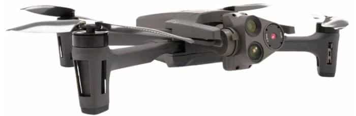
For – Mapping, Inspection & Public Safety
The Parrot Anafi USA is a high-performance, commercial-grade drone crafted to meet the needs of various industries like public safety, inspection, and agriculture. It combines powerful imaging capabilities with a secure data handling process, making it an ideal choice for professionals in need of a compact, robust, and easy-to-use drone.
Equipped with a 32x zoom, centred around a 4K HDR camera with a 1/2.4″ CMOS Sony sensor, the Anafi USA offers excellent video and image capture capabilities. The three-axis hybrid stabilisation ensures clear images and smooth footage, even in challenging weather conditions. Furthermore, the drone features two other cameras – a FLIR Boson module for thermal imaging, and a 21 MP visible RGB camera, creating a unique 3-camera setup.
One key feature of the Anafi USA is its flight time. This drone can stay airborne for up to 32 minutes per battery charge, and it operates within a range of up to 4 km (2.5 miles). The drone’s top speed is 55 km/h (34 mph), allowing it to cover large areas efficiently. It’s also a lightweight and foldable drone, making it portable and easy to set up. Additionally, the drone offers automatic return-to-home and geofencing capabilities, further enhancing operational safety.
The Anafi USA ensures data security with AES-XTS 512-bit encryption for the transmission of photos and videos. This level of encryption ensures the protection of sensitive data from potential breaches.
9. DJI Agras T20P
For – Agricultural Mapping & Spraying
The DJI Agras T20P is an agricultural drone that offers superior performance and versatility. This device has a Dual Atomised Spraying System, Active Phased Array Radar, and Binocular Vision capabilities. The drone supports multiple operations, such as surveying, mapping, spraying, and spreading. The tank has a carrying capacity of up to 20 kg for spraying and up to 35 L (25 kg) for spreading. The T20P combines mapping, spraying, and spreading functions and features a UHD camera and adjustable gimbal for real-time image capture. It has a turbocharged remote controller for efficient mapping and intelligent route planning. The core components are designed to withstand harsh farmland environments and have undergone rigorous testing for reliability. The T20P also features fast charging capabilities and is compatible with the DJI Agricultural Cloud Platform for field patrols, growth analysis, and variable spraying/spreading operations.
For a comprehensive list of drones for crop spraying, click here
10. DJI Mavic 2 Enterprise Advanced
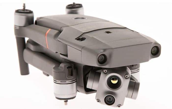
For – Mapping, Inspection & Public Safety
The DJI Mavic 2 Enterprise Advanced is a sophisticated and portable commercial drone packed with powerful features, making it suitable for a wide range of professional applications, including inspection, search and rescue, and public safety.
One of the notable features of this drone is its dual imaging system. The Mavic 2 Enterprise Advanced is equipped with a high-resolution 48 MP visual camera and a radiometric thermal camera, which provides 640×512 thermal resolution. This dual-sensor setup enables users to capture detailed imagery in a variety of conditions and applications, from identifying missing persons in search and rescue operations to detecting thermal anomalies during industrial inspections.
Another standout feature is the inclusion of RTK (Real-Time Kinematic) technology. With the addition of an RTK module, the Mavic 2 Enterprise Advanced can achieve centimetre-level accuracy in its positioning data, making it ideal for precise mapping and surveying tasks.
When it comes to flight performance, the DJI Mavic 2 Enterprise Advanced has a flight time of 31 minutes and a maximum speed of 45 mph. This drone also has a maximum transmission range of up to 10 km with OcuSync 2.0 technology, allowing for safe and reliable operation over a considerable distance.
The Mavic 2 Enterprise Advanced also prioritises safety and security features. It comes with DJI AirSense, which uses an integrated receiver to alert drone pilots of ADS-B signals from nearby manned aircraft, enhancing airspace safety. Additionally, it features password protection for the drone and its onboard data, adding an extra layer of security.
For added versatility, the Mavic 2 Enterprise Advanced can be equipped with additional modular accessories like a spotlight, speaker, and beacon. This modularity enables customisation to fit a range of professional applications.
Regulatory Considerations
Navigating the regulatory landscape for commercial drones can be a complex task as it varies from country to country and even among regions within a country. In this section, we’ll focus on the regulations in two major regions: the United States and the United Kingdom. It’s crucial to remember that laws change, and it’s always essential to stay updated with the latest rules from authoritative bodies.
United States
In the US, the Federal Aviation Administration (FAA) is the governing body responsible for regulating all civil aviation, including the use of commercial drones.
Commercial drone pilots must comply with the FAA’s Part 107 rule (Small U.A.S. Rule), which covers drones weighing less than 55 pounds (approximately 25 kilograms) performing non-recreational operations. Key aspects of Part 107 include:
Commercial drone pilots must hold a Remote Pilot Certificate from the FAA, requiring passing an aeronautical knowledge test.
Drones must always be within the pilot’s visual line of sight (VLOS).
Drones cannot be flown over people not directly involved in the drone’s operation, over moving vehicles, or at night (unless equipped with certain anti-collision lighting).
Maximum altitude is 400 feet above ground level (AGL) or within 400 feet of a structure.
Maximum speed is 100 mph (87 knots).
For operations not covered under Part 107, waivers can be requested. Also, drones used for certain operations, such as those beyond the visual line of sight (BVLOS), must be registered with the FAA.
United Kingdom
In the UK, the Civil Aviation Authority (CAA) regulates commercial and recreational drone use. Here are some key regulations for commercial drones:
Commercial drone pilots need to obtain an Operational Authorisation from the CAA, requiring passing a theoretical examination and a practical flight assessment.
There are different categories of flights: Open, Specific, and Certified. Most commercial operations fall under the Specific category, which requires an Operational Authorisation.
Drone pilots must not fly above 400 feet.
Drones must not be flown within 50 meters of people and properties not under the control of the pilot and not within 150 meters of congested areas and organised open-air assemblies of more than 1,000 persons.
As with the FAA in the US, certain operations like BVLOS require additional permissions from the CAA.
Importance of Responsible and Legal Drone Operation
The use of drones, while offering immense benefits, also raises concerns about safety, privacy, and security. Incidents such as near misses with manned aircraft, invasions of privacy, or the use of drones for illicit activities have highlighted the importance of responsible and legal drone operations.
Adherence to regulations is crucial not only to maintain safety but also to ensure the continued growth and public acceptance of the drone industry. Irresponsible drone use can lead to accidents, invasion of privacy, and other unwelcome consequences, which could result in stricter regulations or even a public backlash against drone technology.
It’s also important to note that not following the regulations can result in substantial penalties, including fines and imprisonment. Therefore, before embarking on any commercial drone activity, it’s essential to understand and comply with the relevant laws and regulations and to operate drones in a safe and responsible manner.
Please Note
The information contained in this blog post, including references to regulations and legal considerations surrounding commercial drone use, is provided for general informational purposes only. This article is not presented as legal advice of any kind, and we can’t guarantee that the information is accurate, complete, or up-to-date. While we strive to provide accurate and timely information, laws and regulations often change, and the application of certain laws can vary widely based on the specific facts and circumstances involved.
As such, the information provided here should not be used as a substitute for legal advice from a licensed attorney who is authorised to practice in the jurisdiction. Always consult with your local aviation authority responsible for drone safety, utilise the services of a licensed drone operator, or seek advice from a qualified attorney regarding any legal questions or concerns you may have.
We explicitly deny any and all liability with regard to actions taken or not taken based on any or all of the content of this blog post. The use of the information provided herein does not create an attorney-client relationship between the user and us.
Final Thoughts
In this blog post, we’ve explored the transformative impact of commercial drones across a range of industries, from filmmaking and agriculture to real estate and emergency services. We’ve highlighted key factors to consider when selecting a drone for business use and delved into some of the top commercial drones on the market in 2023.
Regulation is key in this context, and we have underscored the importance of understanding and abiding by these rules. We looked at regulations in the US and the UK, emphasising the shared global focus on safety, privacy, and legal compliance.
The future of commercial drones is bright, with advances like AI integration and swarm technology paving the way for even more disruptive potential. We encourage businesses to consider how commercial drones could enhance their operations, offering improved efficiency, cost-effectiveness, and unique perspectives.
As we navigate this technological revolution, with careful selection and responsible operation, commercial drones can become invaluable tools in your business, pushing boundaries and opening up a world of opportunity.