
As drones continue to become more popular and accessible, they are being used in several ways for many commercial applications. The largest commercial application of drones is in the construction industry. Drones are perfect for a variety of construction tasks, from surveying construction sites and producing detailed maps to helping with site surveillance and security. In this blog post, we’ll explore the different types of drones that are best suited for construction projects, as well as discuss some of their key benefits. We’ll also provide a list of some of the best drones for construction purposes, based on our own research. Finally, we’ll offer some advice on how to choose the right drone for your construction project, based on your specific needs. So, if you’re looking to start a drone program for your construction company, keep on reading.
Uses Of Drones In The Construction Industry
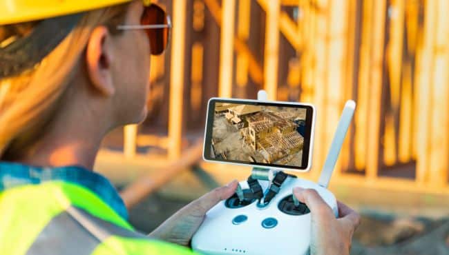
Drones are quickly becoming a vital tool for construction companies. These unmanned aerial vehicles can be used in a number of ways, including to survey the land before construction begins, monitor progress during construction, and inspect the condition of structures after they’ve been completed.
Drones can also be useful for inspecting infrastructures such as roads, bridges, and cable lines.
As drones are easily deployed and cheap to operate, companies can use them on a regular basis to collect data about their project Not only can this help avoid costly delays and errors, but it can also help identify potential problems early on.
Drones also provide many benefits, many tasks such as surveying an area or inspecting structures may pose some risks to humans if the terrain is dangerous or the structure is high and unstable.
Drones allow workers to carry out these tasks from a safe vantage point and complete the job much faster without compromising data integrity.
Drones are also being used for surveillance and security purposes, many equipment like heavy machinery used for construction projects is highly valuable and is often the target of criminal gangs.
Drones can be used to strengthen the security around the site, especially during times when there are no staff around. There are specific types of drones that are suitable for security purposes, these drones usually have longer flight times or are tethered to a power source for continuous surveillance.
This allows security personnel to have a clear aerial view of the entire site and spot any suspicious activity and keep track of any unidentified persons within the site perimeter.
Types Of Drones Used For Construction Projects
The best drone for construction tasks will depend on what it will be used for and the company’s budget.
There are two types of drones that are popular for construction projects, they are fixed-wing and multirotor. They both have their pros and cons, however, multirotor drones seem to be the more popular option as there are more for these types of drones.
Multirotor drones usually have 4-8 rotors, have a flight time of around 30-50 minutes and some like the Matrice 200 and 300 series come with multiple payload capabilities.
One of the advantages of multirotor drones is their manoeuvrability, because of their design, they don’t require a lot of space to take off and land. Multirotor drones can also change directions swiftly and hover in mid-air. These features make them great for things like inspection and site surveillance.
It used to be the case that multi-rotor drones were limited by their flight times in comparison to fixed-wing drones. However, this is starting to change as technology advances, the new Matrice 30 can operate for 46 minutes, while the Matrice 300 RTK has a flight time of 43 minutes when carrying a payload of 700g.
Another advantage of multirotor drones is their compact design, they are much smaller than most fixed-wing drones and some like the Matrice drones can be folded up for easier storage.
Fixed-wing drones are shaped like a plane and are much larger than multi-rotor drones, this has its advantage as they are more stable in tough weather conditions.
The most popular fixed-wing drone is probably the SenseFly’s eBee series, there are others like the Delair UX11 and Autel DragonFly, which also perform well.
These types of drones are great for mapping large areas of land as they are usually faster and have longer flight times than multi-rotor drones.
Fixed-wing drones also require more space for taking-off and landing, which may not always be convenient around a construction site. They are also a lot harder to operate and are not as versatile as multi-rotor drones.
An alternative to both fixed-wing and multi-rotor drones is the VTOL drone, these are kind of a hybrid of both multi-rotor and fixed-wing drones without the limitations of both.
The most popular VTOL drone is probably the WingtraOne GEN II, although there are a few other options like the Atmos Marlyn and the DeltaQuad Pro.
The cheapest of these drones is the multi-rotor drone, while both VTOL and fixed-wing drones have a similar price range.
Best Drones For Construction
If you are in the construction business and looking to integrate drones into your workflow, you must understand that there is no one drone that will fulfil all your requirements.
You will have to choose one that meets most of your needs and is within your budget, the most popular drone for construction is probably the DJI Phantom 4 Pro RTK. it is also one of the cheapest commercial-grade drones, which also plays into its popularity. The drone provides centimetre-level accuracy for surveys and is suitable for most mapping requirements for construction projects.
The list below is just a small selection of drones that are suitable for construction-related tasks, however, you should definitely search around as there are always new models being released and one of them may be more suitable for your needs.
All the drones on this list have been developed for commercial purposes and as such come with high-end cameras, and many are compatible with different types of remote sensing equipment such as thermal cameras, LiDAR sensors and gas detectors.
All of these drones come with some kind of GPS correctional technology like RTK or PPK or a combination of both. This is the technology that allows these drones to calculate centimetre-level GPS data and embed the data within every image. The georeferenced data are then used by photogrammetry applications to develop accurate maps and 3D models.
Most of these drones come with an IP rating which allows them to be operated in adverse weather conditions, the only exception is the Phantom 4 RTK, which does not come with any kind of IP rating.
DJI Phantom 4 RTK
This is probably the most popular mapping drone and is perfect for small-medium-sized construction projects. Compared to most of the other drones on this list, it’s relatively small, compact and weighs less than 1.4kg. The drone comes with a 20MP camera that can also record 4k videos at 60fps. With its RTK module and Time-sync system, the drone can achieve centimetre level accuracy when flown at 100m with a GSD of 2.7cm. This drone comes with a flight time of 30 minutes, which is one of its weaker points and the drone cannot be operated in the rain. Other than its flight time and the limited weather conditions it can operate in, the Phantom 4 RTK is a fantastic drone for mapping and is probably the best overall for bug
DJI Matrice 300 RTK
The Matrice 300 RTK from DJI, is the most advanced drone in the Matrice series, it’s a robustly built drone that can be operated in the harshest of weather conditions. The Matrice 300 RTK comes equipped with a multitude of advanced functions that make it one of the best drones for commercial applications. The drone comes with a maximum flight time of 55 minutes, although this is without a payload. It has multiple safety features including several redundancy systems, 6-way obstacle sensing, top and bottom anti-collision beacons and an ADS-B receiver. The drone is compatible with a host of advanced payloads, including ones with multi-sensors. This makes it a very versatile drone that can be used for mapping, inspection and surveillance.
DJI Matrice 210 RTK
One of the more advanced drones in the Matrice 200 series, the 210 RTK is a multi-purpose drone that comes with some impressive features. It’s an all-weather drone that can be operated in extreme cold and hot environments and it has a flight time of 33 minutes. The drone is compatible with different types of payloads which makes it suitable for different types of construction-related tasks. The drone comes with a few safety features including an anti-collision beacon ADS-B receiver and redundant systems for the barometer and IMU.
MicroDrone mdMapper 1000DG
The mdMapper 1000DG from MicroDrone is one of the best drones for surveying and mapping. The drone uses an innovative technology called Direct Georeferencing or DG to calculate the exact location of every pixel on an image. This is an alternative to PPK and RTK and provides accurate geospatial data without the need for GCPs. The drone comes with a Sony RX1R II 42.4MP camera which is supported on a nadir mount and provides 1.6cm GSD from an altitude of 120m. The drone has a flight time of around 45 minutes and can survey 80 ha in one mission. MicroDrone has several drones that have similar features to the mdMapper 1000DG, the main difference being the payload. They also have their own photogrammetry software called mdInfinity which is included with any purchase of one of their drones.
SenseFly eBee X
The eBee X from SenseFly is probably the most popular fixed-wing drone for survey-grade mapping and can achieve 1.5cm accuracy with its onboard RTK/PPK solutions. The drone has a maximum flight time of 90 minutes and can survey 220 ha in just one hour with a GSD of 2.9 cm pp. The eBee X is compatible with 9 different cameras including the SenseFly S.O.D.A 3D, Aeria X and SenseFly Corridor. The drone also comes with direct georeferencing technology that does not require any GCPs for accurate geospatial data.
Delair UX11
The Delair UX11 is an exceptional fixed-wing drone that has been engineered for large-scale surveying. The drone weighs less than 1.5kg, which is light for a drone of its type, and it can be flown in tough weather conditions. The drone has a flight time of around 1-hour in which it can map 120 ha or around 9.6 km² in an 8-hour day and provides centimetre-level accuracy with 1.7cm GSD.
WingtraOne GEN II
For large-scale surveying and mapping, the WingtraOne GEN II is probably the best overall drone. It’s a robust drone that comes with an IP68 rating and has been tested to military standards for durability in the harshest of environments. The drone comes with a 42MP Sony RX1R II camera and comes with a PPK GNSS receiver. It’s one of the few drones on this list that can provide sub-centimetre GSD and 1cm horizontal accuracy. In fact, the company has tested the GNE II drone against its main competitors and the data shows that the drone provides accurate results while covering more ground.
DeltaQuad Pro #Map
An impressive drone with the best overall specs, it has a flight time of 110 minutes and can map around 1200 ha in that time. The drone is compatible with a range of cameras including the 61MP Sony A7R-IV. It has a fully redundant flight system and an ADS-B receiver for safer flight operations and the drone has a maximum range of 50km, making it perfect for BVLOS operations. The drone can provide sub-centimetre GSD readings and 1cm geospatial data, making it one of the most accurate drones for aerial data acquisition.
Atmos Marlyn
A futuristic-looking VTOL drone, the Marlyn from AtmosUAV is an exceptional drone for large-scale mapping requirements. It has three layers of special foam padding for all-weather durability and comes equipped with a Sony RX1 RII camera and a PPK GNSS receiver.
Drones For Construction Site Security
Although some of the drones like the Matrice 300 and 210 can be used for site security, there are far better options for this specific operation.
The best drones for security and surveillance are known as a drone-in-a-box solution.
These drones are stored in a box from which they take off, land and recharge. They are fully automated, and both the drone and the box are built to be operated in all types of weather conditions.
Percepto is one of the more popular companies that are leading the way for this type of drone technology. Their drone-in-a-box solution is fully autonomous, they can be scheduled to operate at certain times, or they can be triggered in response to suspicious activity. These drones and their base stations have been built to operate in any type of weather conditions and are being used to bolster security for high-value sites.
Another company that is leading the way with a drone-in-a-box solution is Easy Aerial, they provide drone security solutions for Government & defence, First Responders and Commercial applications.
Easy Aerial provide 3 types of drone-in-a-box solutions, free-flight, tethered and a hybrid of both.
They have 5 drones that can be customised with different types of payloads and each drone comes with an Easy Guard base station. All their drones have a flight time of around 45 minutes, can be operated in any type of weather conditions and some of them can be tethered to the base station for continuous surveillance.
DJI released their first drone in a box solution for the new M30/30T models called the DJ Dock. These drones come with a multi-sensor payload which includes a high-resolution thermal imaging camera and night-vision sensor as well as a 48MP RGB camera. It has a flight time of 41 minutes and a range of 15km, there are several safety features like flight redundancy systems, obstacle avoidance sensors and an ADS-B receiver. The DJI Dock can recharge the drone to 90% of its capacity in 25 minutes and so it can be deployed routinely whenever it is required.
Final Thoughts
Drones are a powerful tool and proving to be very beneficial in the construction industry. As we have seen from this article, they have a wide range of uses, from mapping and progress monitoring to site surveillance and security. Drones will definitely make life easier for construction managers and surveyors, the process of capturing data for maps, 3D models, inspection and other tasks will be more efficient, and less risky and companies will save money on equipment and LABOUR which will improve overall ROI.