
Drones are having a huge impact on precision agriculture, their technology is changing the way farmers, agronomists, crop insurers and other interested parties capture field data for analysis, and decision making. There are a lot of drones for agriculture, with the use of different types of remote sensing technology drones can capture high resolution images. These images are then processed by photogrammetry software and provide a wide range of data points that will be used to analyse crops and allow farmers and agronomists to make informed decisions on agricultural operations.
How Are Drones Used For Agriculture?
The use or application of drones in agriculture are many, with the detailed maps that can be generated from drone aerial imagery, users will be able to extract data that will be helpful in many aspects of running an agricultural farm.
Drones are easily deployable which will allow farmers, agronomists, insurers etc to frequently scout fields and acquire crop and soil data regularly. This will keep them on top of any issues that may be identified and take action quickly so that crop production is not compromised, and the yield target is met.
Many commercial drones come with different types of camera sensors, for example, the DJI Phantom 4 Multispectral comes with a multispectral camera. These types of cameras are very useful for capturing health data for crops.
Using multispectral imagery, farmers (or any other interested parties) can generate different types of vegetation index maps that will allow them to analyse plant and soil health. Frequent analysis of data through multispectral maps will help in identifying any issues in relation to the health of the crops/soil before any visible symptoms start appearing.
This will help farmers/agronomists to quickly put in a plan of action and mitigate the problem before it gets worse.
The benefits of using drones for agriculture are numerous, they allow users to acquire accurate field data very fast which allows for quicker and more informed decision making.
Data captured via drones will help with optimising irrigation management, accurate stand counts, precise application of fertilisers and pesticides, planting seeds and even help with insurance claims in the aftermath of extreme weather conditions or natural disasters.
Drones also provide sustainable farming solutions, agriculture is a very important industry for the world as its one of the starting points in our food chain. The industry is affected by political turmoil, economic challenges and climate change, to meet these challenges and mitigate their problems, those in the industry will need to innovate sustainable farming methods and drones are proving to be part of that solution.
Best Drones For Agriculture
There are a lot of drones that are suitable for agricultural use, many of the drones on this list are compatible with different types of cameras. For example, the DJI Matrice 300 RTK can be fitted with multiple payloads and supports third party devices from Sentera and Slantrange.
Drones that are compatible with different payloads are resourceful as they will allow users to capture various types of aerial data without having to purchase another drone.
This is not an exhaustive list, however, my research has led to me believe they are the most popular in this area of application.
When it comes to aerial data collection, there are two types of drones, fixed-wing and multi-copters. Fixed-wing drones are a lot more expensive, but they are more robust and have a longer flight time. These drones are the best option for gathering aerial data for large areas of land as they are quicker and have a good flight time. However, there are not a lot of fixed-wing drones (when compared to multi-copters) so you are limited by choice, having said that, the ones on this list are the best for commercial drone applications.
Multi-copters are more versatile and there are a lot of options, however, this list is dominated by DJI, who are the leading drone company in the world. Multi-copter drones are easier to operate and they are cheaper than fixed-wing drones, they are usually the best option for mapping and gathering crop data for small to medium sized farmlands.
DJI Phantom 4 RTK
The DJI Phantom 4 RTK drone features a 1″ sensor capable of capturing 20MP images and comes with an RTK GNSS receiver, enabling survey-grade accuracy for advanced mapping and GIS capabilities. It is DJI’s most popular drone for commercial use and is suitable for agricultural field mapping. One reason for its popularity is because it is relatively cheap when compared to its competitors but still provides accurate data for 2D maps and 3D models. With its high resolution camera and RTK GNSS receiver, the drone can provide Ground Sample Distances of 2.74 cm and 5cm absolute horizontal accuracy. The only limitation is probably its flight time, which is around 30 minutes, so it’s best suited for smaller mapping jobs or you can purchase a couple of extra batteries to extend the flight time for larger areas. It comes with a dedicated photogrammetry app for flight planning and data processing but is also compatible with the more popular mapping software like Pix4D, Drone Deploy and Precision Hawk.
DJI Phantom 4 Multispectral
This drone comes with 5 camera sensors that capture image data that are invisible to the human eye. It has an additional RGB sensor and comes with RTK GPS correctional technology for centimetre-level accuracy. The drone has an irradiance sensor on top that captures sunlight data from all directions, this helps with consistent data accuracy throughout the day and helps capture more accurate vegetation indices data. The drone will help farmers and agronomists capture a wide range of data points that will help in the management of crop health and make better informed decisions.
DJI Matrice 300 RTK
This multi-copter drone is one of DJI’s most sophisticated drones for commercial applications. DJI Matrice 300 RTK is the ultimate professional drone for demanding commercial applications. Featuring DJI’s reliable flight control system and intelligent piloting features, this drone is simple to use and delivers unrivalled performance. It has a 15km transmission range and has an advanced dual control function that will be suitable for long range missions. The powerful rugged design, with an IP45 rating, means you can fly the drone in harsh weather conditions. The drone has the capacity to carry 3-payloads and is compatible with many sensors including the new DJI Zenmuse L1 LIDAR sensor and the Zenmuse P1 full-frame camera with a 45MP sensor.
DJI Matrice 210 RTK V2
For aerial surveying, this drone is the perfect tool for agricultural mapping. The DJI Matrice 210 RTK drone can carry two payloads and comes with many enhanced features and offers a robust design for use in tough environments. The flight time on this device lasts up to 24 minutes (with two payloads), has a top speed of 50mph and a transmission range of 8km. Like most commercial DJI drones, the Matrice 210 RTK comes with an obstacle avoidance system and an anti-collision beacon for safer flying. With its compatibility with most of DJI’s cameras and third-party sensors, this drone is a good choice for agricultural operations.
WingtraOne
WingtraOne is a fixed-wing drone that has vertical lift-off and landing capability and has an IP67 rating as well as a military-grade rating for its design. It has a flight time of around 55 minutes (depending on its payload) and with its speed and PPK/RTK features, the drone can survey and map large areas of land quicker than most other drones. Its compatible with a range of cameras and this includes the full-frame 42MP Sony RX1R II and the Micasense Altum which is one of the best multispectral/thermal cameras.
SenseFly eBee X
The eBee X is the flagship drone from SenseFly, it’s a lightweight fixed-wing drone that is launched by hand and can be fixed with a range of cameras that makes it suitable to collect data for different industries. It has a flight time of 60 minutes but can be extended to 90 minutes with an endurance battery. It has RTK/PPK capability for centimetre-level accuracy and its well-built design makes it suitable to fly in harsh weather conditions.
SenseFly eBee Ag
This drone has been specifically designed for agricultural mapping, it comes with a dual camera that consists of a RGB and multispectral sensor. It has an RTK module for survey-grade accuracy and has a maximum flight time of 55 minutes.
Quantix Mapper
The Quantix Mapper is a fixed-wing drone with vertical take-off and landing capability. It has a flight time of 45 minutes and can map 400 acres of land on one battery charge. It comes with an 18MP RGB and multispectral camera and can capture accurate geo-referenced images which can be viewed right away with the accompanying Quick Look HD mobile app. It’s a drone that was originally built for military purposes but is now used for commercial purposes.
DraganFlyer Commander Ag Pro
One of the lesser known drones on this list, the DraganFlyer Commander Ag Pro is an impressive drone that is built from carbon fiber, making it lightweight but yet still very durable. The arms have a foldable design for extra portability and the drone has a decent flight time of 35 minutes. It comes with a multispectral camera from Micasense and is a great solution to capture highly detailed crop data throughout the year to monitor and optimise farming operations.
Atmos Marlyn
One of the newer fixed-wing VTOL drones, the Atmos Marlyn is a commercial drone that can capture accurate geo-referenced images thanks to its internal PPK GNSS receiver. Its design allows it to take off and land like a quadcopter, which makes it more versatile than traditional fixed-wing drones and it is compatible with different cameras which includes the Sony XR1R II and the Micasense Rededge-MX. It comes with its own flight planning software called the Atmos Navigator and the images captured by the drone can be processed by most of the well-known photogrammetry applications. It’s a well-built drone that can withstand winds up to 28mph and has a maximum flight time of 50 minutes.
MicroDrones
This is a UAV company that is based in Germany but has offices in the USA and Canada. They manufacture commercial grade drones that come with advanced LIDAR sensors and/or professional cameras like the 42MP full-frame Sony XR1R II. Some of the drones can also be modified to attach third-party payloads and they are can be flown in tough weather conditions and have long flight times of 45 minutes. They have a range of drones that are suitable for agricultural use, these include the mdMapper 3000µoG VHR, which comes with a PhaseOne iXM 100MP camera, the mdLIDAR 1000LR which comes with an advanced LIDAR sensor and 26MP camera and the mdLIDAR 1000HR which also comes with a high resolution LIDAR sensor and camera. MicroDrones also have their own photogrammetry software called mdInfinity that will allow users to process aerial image data into different types of digital maps and 3D models.
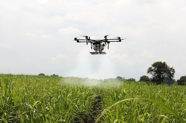
Drones For Crop Spraying
Spraying crops with chemicals to fight pests and disease is relatively new and the technology has not been globally accepted yet. However, crop spraying with drones has shown to be effective and safe and it will not be too long before it gets widespread acceptance as part of agricultural operations.
The most well-known drone for crop spraying is the DJI Agras series, the largest of these is the Agras T30, which comes with a 30L tank and can be fitted with a 30L spreader for planting seeds and spreading mulch.
It’s an advanced spraying drone that comes with a radar system that can detect obstacles from all directions and automatically avoid them during spraying missions. It has 16 powerful nozzles that have a spraying distance of 9 meters and a pumping system that provides a flow rate of 8 litres per minute. The drone can be flown in all weather conditions thanks to its design and IP67 rating. With an advanced navigation system and RTK GNSS receiver, the drone can accurately cover around 240 acres of land in an hour.
Other drones in the Agras series include the T20, T16 and T10, the main difference between the drones are the amount of liquid the drone can carry, the number of nozzles and their overall flight time.
Future Of Drones In Agriculture
According to many reports, drones in agriculture is a multi-billion dollar industry and is set to grow rapidly over the next few years.
As the technology advances and regulations are relaxed, the future of drones in agriculture looks bright as more farmers start adopting drones into their workflow. As we have seen in this article, drones offer a huge range of benefits for the agricultural industry and as they become more accessible, their technology will help revolutionise many aspects of agricultural operations.
What might slow down the adoption of drones in many countries for agricultural use is the knowledge gap, as any new technology takes time to learn and utilise properly.
However, even if the adoption rate is slow, there is no doubt about the impact drones will have in the agricultural industry. Farmers who have invested in this technology are seeing great benefits and it will not be long before drones become synonymous with tractors in the field of agriculture.
How Much Do Agricultural Drones Cost?
Commercial drones are way more expensive than your regular consumer drones, drones for agriculture can cost anything between $5,000 – $25,000. For example, the DJI Phantom 4 Multispectral costs around $10,000, while a fixed-wing drone like the SenseFly eBee X costs $20,000+.
Final Thoughts
The benefits of drone for agriculture is huge and as the technology is improved, it will be adopted more widely and play a huge role in the way agricultural tasks are completed. There are a lot of drones that are suitable for agricultural use, from capturing highly detailed geo-referenced images for maps to intelligent crop spraying, drones are playing a huge role in precision agriculture and helping with developing sustainable farming methods.