
Drone technology is always advancing and is increasingly being utilised in public services, one area where drones are slowly being adopted into the workflow is in forestry management. They are ultra-portable and lightweight and provide many benefits such as the ability to cover large areas quickly and capture high-resolution images and videos that can be used for forestry management. Drones can be used for a variety of tasks in forestry management, including mapping and surveying, monitoring forest health, helping against forest fires and for surveillance purposes to prevent illegal logging and other criminal activities. They can also be used to observe and track wildlife, and to assist in search and rescue operations. The use of drones in forestry management is in its infancy, but the results are promising, and the applications will only grow as the technology gets more advanced and accessible. In this article, we shall explore the use and benefits of drones in forestry and the type of drones that are best suited for these applications.
Benefits Of Using Drones For Forestry Management
There are a variety of benefits that can be realized by using drone technology for forestry management. Some of the main ones include:
Faster Data Acquisition & Reduced Costs
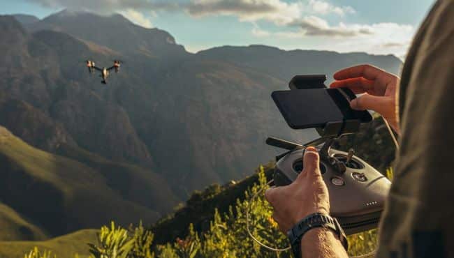
Drones are small, lightweight and ultra-portable, this gives them a distinct advantage over traditional methods of gathering aerial data.
They can be easily deployed and acquire data much faster than something like a manned aircraft or satellites without compromising on data accuracy.
Drones can help reduce the time and costs associated with conducting forestry surveys and managing forest resources. They can also help identify areas that need attention, and they can provide real-time information about the health of trees and any other vegetation.
Identifying any health-related issues early on will provide forestry professionals more time to plan a course of action and remedy the situation.
Whether it’s finding pest-related disease, identifying soil contamination, tracking a wildfire or surveillance of any illegal activity, many drones come with multispectral or thermal imaging cameras that will allow easier identification of these issues without the related costs of hiring a manned aircraft.
Enhanced Safety
Forests can be difficult to navigate on foot, the terrain is uneven and can be dangerous and in the event of something like a forest fire or some other disaster, it’s even more dangerous to investigate and collect data on the ground.
Drones provide a much safer way to collect aerial data, fly surveillance missions and carry out search and rescue operations in forests and wooded areas.
As drones are easy to fly and ultra-portable, they can be deployed very quickly and missions can be carried out on a more regular basis without putting personnel at risk.
Greater flexibility
Drones offer greater flexibility when it comes to scheduling activities, as well as the ability to move around freely within a given area. This makes them easier to use than traditional vehicles for managing forest resources on a day-to-day basis.
Reduced Use Of Fossil Fuels
Another benefit of using drones is their zero use of fossil fuels, this not only helps with fighting climate change but also reduces the need for small, manned aircraft which are very expensive to operate and use a lot of fossil fuel.
Application Of Drones For Forestry
Drones are now used in forestry to help manage forests and monitor the health of trees. They’re also used to map landscapes, measure forest density, and collect data on tree characteristics.
One of the main reasons that drones are such a good tool for forestry is that they allow for precision and accuracy when it comes to spatial data. This is because drones can fly very low to the ground and take high-resolution images and videos that are ideal for mapping purposes.
Drones are also effective at gathering data on tree characteristics like height, diameter, age, and location. This is useful information for monitoring the health of a forest and making informed decisions about how to manage it.
Drones are also used to help in the fight against forest fires, they can be used to collect data about the spread of the fire, its intensity, where more resources need to be allocated and for finding survivors.
Drones are also being used to carry out controlled burns to reduce the impact of forest fires and stop their spread.
Drones can also be used for surveillance and security purposes, they are being used to monitor illegal activity like unlicensed logging and locating criminals or lost people.
Another emerging use of drones in forestry and agriculture is plating seeds, drones are being used to counter the effects of deforestation by planting seeds at a much faster rate than can be done manually. This will help with reducing the effects of climate change and allow forestry professionals to reforest much faster and at scale.
A more comprehensive list of drone use in forestry management can be found in this report.
Types Of Drones For Forestry Management
The most popular types of drones used for forestry management are multi-copter drones, although fixed-wing drones are the better option for surveying and mapping large forest areas.
Both multi-copter and fixed-wing drones have their pros and cons, multi-copter drones are far more flexible and easier to operate, there are also a lot more multi-copter drones to choose from and they are usually cheaper than fixed-wing drones.
One of the main advantages of multi-copter drones is their flexibility, they take off and land vertically which eliminates the need for a large area to start drone missions and they can also hover with little drift which provides lots of advantages such as inspecting a particular area or tree or to deliver some vital supplies for people who are lost or stuck.
Another advantage of multi-copter drones is that they are easy to operate and even beginners who have no experience with flying drones can get a handle on them very quickly. This will reduce the need for extensive training for forestry professionals which will help with saving costs and speed up the process of introducing drones into the workflow
Many multi-copter drones can also be attached with different types of payloads and in some cases drones from the DJI Matrice series, multiple payloads can be attached.
This provides another advantage as you will be able to capture different types of data depending on the mission objective.
One of the cons of multi-copter drones, when compared to fixed-wing drones, is their flight time, although, with advances in design and technology, this is not such a big issue anymore.
Fixed-wing drones are usually more robustly built which allows them to be operated in harsh weather conditions. They also have much longer transmission range and flight times which have obvious advantages such as covering more land and for BVLOS operations.
However, I do believe the best type of drones for forestry management are multi-copter drones as they are cheaper, easier to operate and very versatile which allows them to be used for different mission objectives.
The drones I have listed below are all enterprise-level multi-copter drones, they all come with a high-resolution RGB and thermal imaging camera. I believe a thermal imaging camera for forestry is important especially to identify any health issues, to locate hotspots in case of forest fires and to locate missing people in search and rescue operations.
DJI Mavic 2 Enterprise Advanced
One of the most powerful foldable drones from DJI, the Mavic 2 Enterprise Advanced comes with a dual camera system that is stabilised by a 3-axis gimbal.
The dual camera includes a high-resolution RGB camera that can capture 48MP still images and 4k video footage. The thermal camera can capture images and videos in 640×512 resolution and has an accuracy reading of ±2°C.
Other features include autonomous flight modes, an obstacle avoidance system and DJI AirSense for safer flying.
The drone can be attached with additional accessories like an RTK module, beacon, speakers and searchlights to provide it with extra functionality. The drone has a maximum transmission range of 10km and a flight time of 31 minutes.
DJI M30T
The most powerful foldable drone, the DJI M30T has a compact design but comes with many of the features of its bigger brother the Matrice 300 RTK.
This is a well-designed drone that has been built to be operated in the harshest of weather conditions thanks to its IP55 rating.
An innovative feature of the DJI M30T is its multi-sensor payload which makes it a very versatile drone that allows it to be used for different purposes.
The multi-sensor payload consists of a 12MP wide camera, a 48MP zoom camera, a 640×512 thermal imaging camera and a laser range finder. There is also a separate FPV camera that comes with night vision technology.
The drone has one of the longest flight times for a multi-copter at 41 minutes and comes with DJI’s latest OcuSync transmission technology for a maximum range of 15km.
The drone also comes with many safety features including an omnidirectional obstacle avoidance system, an ADS-B receiver and an advanced redundancy system.
DJI Matrice 300 RTK
The most advanced drone on this list, the DJI Matrice 300 RTK is an enterprise-level drone that is suitable for use in many commercial applications.
This is a heavy-duty drone that can be operated in all types of weather conditions and has a maximum flight time of 55 minutes, although this time can only be achieved without a payload.
Speaking of payloads, the Matrice 300 RTK, is one of the few drones on the market that can be attached with different types of payloads. This will allow drone operators to capture different types of data from one drone mission.
The Matrice 300 RTK is compatible with most of the Zenmuse payloads including the multi-sensor H20T, the full-frame P1 camera and the L1 LiDAR sensor.
The drone has several redundancy systems as well as advanced obstacle avoidance systems for safer flying.
Parrot Anafi USA
The French company, Parrot, has two drones with dual camera systems, the Parrot Anafi Thermal and Parrot Anafi USA.
The USA version meets the BLUE UAS standards which among other requirements puts a huge emphasis on the security of data transmission from a drone so that it is suitable for use by the US DoD.
The Parrot Anafi USA is one of the lightest enter-prise level drones and the lightest drone on this list.
It’s a small foldable drone with an innovative design that has an IP53 rating, making it suitable for operations in all types of weather conditions.
The drone camera has multiple sensors, it has a 21MP wide and zoom camera and FLIR Boson thermal imaging sensor.
The camera is stabilised by a unique 5-axis hybrid gimbal which consists of a 2-axis mechanical gimbal and 3-axis electronic gimbal.
The drone comes with several autonomous flight modes but has no obstacle avoidance system like the other drones on this list.
Autel Evo II Dual 640T
One of the few commercial drones from Autel Robotics, the Evo II Dual 640T comes with some impressive features.
The drone has a dual-camera system that consists of a 48MP 1/2-inch sensor that can also record 4k videos and it also has a thermal imaging sensor.
Other advanced features include an omnidirectional obstacle avoidance system, autonomous flight modes, 38 minutes of flight time and a 9km transmission range.
Final Thoughts
As we have seen from this article, drones provide a new, safer and more efficient way to collect data about forests. Their ultra-portable and easy-to-deploy design provide a huge advantage over ground-based data collection methods.
Faster data acquisition leads to identifying issues early that will allow forestry professionals to put a plan of action in place and remedy the issue as fast as possible.
However, drones are not being used just to monitor the health of forest trees, they are also being used for inventory count, identifying invasive species, monitoring illegal activities and helping with search and rescue missions.
Hello Mr. Minhaj,
Please advise me on purchasing a camera Drone that will function well to cover a 75 acre woodsy farmland. I have a certified tree cutter ready to cut and thin trees for a government CRP program. Just wanted you to recommend a Drone Camera to survey the trees before and after cutting the trees.
Thanks,
William
Cell: 510-506-2915
Hi William
Dear William,
Thank you for reaching out to me with your query. It’s exciting to hear about your upcoming project and I’d be delighted to provide you with the guidance you need for choosing the right drone.
In terms of drones, there are several options available, each with their own unique benefits. Primarily, I’d recommend considering drones with a high-resolution camera or a multispectral camera, depending on the specific data you wish to capture.
A drone equipped with a high-resolution camera would be ideal if you want to take detailed photographs and videos before and after the tree cutting. This kind of drone can help you document the process and provide a visual story of your project. High-resolution imagery is also beneficial if you want to examine the health of individual trees, or the specific areas of your woodland where cutting has occurred.
For instance, the DJI Phantom 4 Pro V2.0 offers a 20MP camera and can record in 4K, which would provide exceptional detail. It also has a good flight time and range, allowing you to cover the entirety of your 75-acre property without the need for multiple flights.
On the other hand, a drone with a multispectral camera can capture data beyond what our eyes can see. This technology divides the spectrum into multiple bands and can provide information on plant health, biomass, and chlorophyll levels. This can be particularly helpful if you’re monitoring the health of your forest before and after cutting, as well as for longer-term forest management strategies.
For this purpose, I would suggest considering the new DJI Mavic 3 Multispectral drone. It is specifically designed to provide insights about crops and vegetation, which could prove quite useful in your scenario.
Remember, each drone and camera option will come with its own learning curve and may require different software or hardware for processing and interpreting the data collected. I recommend considering what kind of data you’ll find most useful in your project before making your choice.
I hope this advice helps! If you have any other questions, feel free to ask.
Best Regards,
Minhaj