
In the evolving landscape of farming, technology plays a pivotal role. From GPS-guided tractors to automated irrigation systems, these innovative tools are shaping the future of agriculture. Among the myriad of technological advancements, one of the most transformative developments is the use of drones in agriculture. These high-tech devices are not just remote-controlled toys; they are becoming indispensable tools in farming, providing critical data and helping farmers to increase yield, reduce crop damage, and manage resources more efficiently. The best drones for agriculture offer a game-changing perspective that could potentially redefine traditional farming methods.
Growth Of Drones In Agriculture
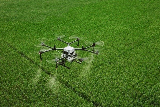
Drones have soared in popularity in the agricultural sector due to their versatility and efficacy. They are used in various applications, including crop monitoring, irrigation management, livestock tracking, crop spraying, etc. With the ability to capture high-resolution images and data, drones allow farmers to have an eagle’s eye view of their fields, enabling precision agriculture like never before.
The impact of these aerial tools is reflected in the staggering growth projections for the agricultural drone market. As per recent analyses, the global market for agricultural drones is anticipated to reach a formidable $20 billion valuation by 2030, with a robust Compound Annual Growth Rate (CAGR) of 29%. The hardware sector of this market, encompassing drone bodies and accompanying physical components, is set to witness significant growth, projected to hit a valuation of $13.6 billion by the conclusion of the forecast period.
Looking at geographical market distribution, the U.S., a major adopter of drone technology, is estimated to have a market worth of $862 million. China, meanwhile, is on a fast track, expected to experience a remarkable CAGR of 34.3% and anticipated to reach a market size of $4.1 billion by 2030.
This impressive growth underscores the integral role that drones play and are set to play in global agricultural advancements.
Benefits of Drones In Agriculture
Efficiency and Accuracy: Drones allow farmers to collect accurate data quickly and efficiently. They can cover large areas of land quickly, gathering data that would take humans hours or even days to compile. The data collected is also highly accurate, allowing for precise analysis and action.
Cost Reduction: With the ability to closely monitor crop health and identify problem areas, drones can significantly reduce the amount of wasted resources, such as water, fertilisers, and pesticides. This, in turn, can lower overall farming costs.
Improved Crop Health and Yield: Drones equipped with multispectral sensors can identify unhealthy plants that might not be visible to the naked eye. Early detection allows farmers to intervene promptly, minimising potential losses and maximising yield.
Versatility: Drones can be used in a variety of agricultural operations. From mapping and surveying to crop dusting and livestock monitoring, the applications are vast, making drones a versatile tool for farmers.
Challenges of Drones in Agriculture
Regulations: Drone usage in agriculture is regulated by laws that vary by country and even by states or provinces within those countries. Compliance with these regulations can be challenging, especially in regions with stringent laws related to airspace, privacy, and safety.
Technology and Maintenance: While drone technology has advanced rapidly, there is a learning curve involved in operating these devices. Regular maintenance and occasional repairs are also necessary, which can be costly and require specific technical expertise.
Initial Costs: High-quality agricultural drones can be quite expensive, and the cost of additional equipment, such as high-resolution cameras or multispectral sensors, can further increase the initial investment. This may be a hurdle for small-scale farmers or those in developing regions.
Weather Dependence: Drones’ performance and the quality of the data they capture can be significantly impacted by weather conditions. Heavy rain, high winds, or fog can limit their operation.
How Drones Are Used In Agriculture
Precision Farming: One of the key roles of drones in agriculture lies in precision farming. By using drones equipped with GPS and imaging sensors, farmers can generate accurate and detailed maps of their fields. This information enables them to manage their lands more effectively, optimising the use of resources such as fertilisers and water. In turn, this can lead to increased crop yields, reduced waste, and substantial cost savings.
Irrigation Management: Managing irrigation is a critical aspect of farming. Drones equipped with thermal cameras can detect variations in soil moisture across a field, identifying areas that are over- or under-watered. By pinpointing these areas, farmers can adjust their irrigation systems accordingly, ensuring crops get the right amount of water and preventing wasteful over-irrigation.
Crop Health Assessment: Drones can play a vital role in assessing crop health. Using multispectral sensors, drones can detect light reflected off plant leaves. Changes in these reflections can indicate plant stress or disease long before they become visible to the naked eye. This early detection enables farmers to intervene more promptly, safeguarding their crops and their potential yield.
Livestock Monitoring: For those in the livestock industry, drones provide an efficient way to keep an eye on animals. With aerial views, farmers can track the location of their livestock, check for signs of disease or distress, and monitor pasture conditions. This not only improves the efficiency of livestock management but also supports animal welfare.
Crop Spraying: Drones are increasingly being used to spray crops with pesticides, herbicides, and fertilisers. This method of application is not only faster and more efficient than traditional methods, but it can also be more precise, minimising the amount of chemicals used and reducing exposure to non-target areas. Some drones can even be programmed to spray specific areas or individual plants, further enhancing their precision and effectiveness.
Types Of Drones In Agriculture
In the realm of agricultural operations, drones have evolved in a multitude of forms, each with specific capabilities tailored to different tasks. Below, we highlight the most commonly used types of drones in agriculture:
Fixed-Wing Drones: Resembling a traditional airplane in design, fixed-wing drones are characterised by their long, fixed wings. They are typically used for tasks that require long flight times and large coverage areas, such as mapping large fields or monitoring expansive grazing areas. These drones are not capable of hovering in place but can cover greater distances at higher speeds compared to other types.
Multi-Rotor Drones: Multi-rotor drones, including the widely recognised quadcopters (four rotors), are great for precision tasks. They can hover in place, manoeuvre around objects, and take off and land vertically, making them ideal for close-up inspections, crop spraying, or detailed mapping of smaller areas. However, their battery life and speed are generally less than that of fixed-wing drones.
Hybrid Drones: As the name suggests, hybrid drones combine the characteristics of fixed-wing and rotor-based drones. These drones can take off and land vertically like multi-rotor drones, but once in the air, they can transition to flight like a fixed-wing drone. This gives them the advantage of long flight times and large coverage areas while still providing the manoeuvrability necessary for precise tasks.
Each of these types of drones has its strengths and weaknesses, and the choice of which to use depends on the specific needs of the agricultural task at hand.
Best Drones For Agriculture
The best drones for agriculture are typically those with dual camera systems, featuring a high-resolution RGB camera coupled with either a thermal or multispectral camera. Multispectral cameras are often preferred due to their ability to capture a wider range of data, which can be critical for assessing crop health and irrigation needs. Drones equipped with multisensor payloads can offer more detailed, comprehensive insights, allowing for enhanced precision in farming operations. From spotting pests to detecting water stress, these versatile devices are revolutionising the field. Below, we review the top 8 agricultural drones of 2023.
1. DJI Mavic 3 Multispectral
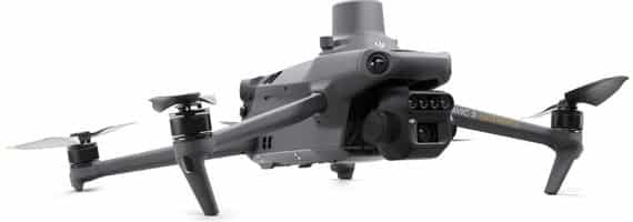
The DJI Mavic 3 Multispectral is arguably the best drone for agriculture, combining advanced technology with practical applications to offer one of the best drone solutions for farmers. The drone is equipped with a 20MP RGB camera and four 5MP multispectral cameras, setting the standard for high-precision aerial surveying, crop growth monitoring, and natural resource surveys.
The 5MP multispectral camera’s capabilities, including near-infrared (NIR) and red edge (RE), empower users with detailed insights into crop health and growth patterns. This advanced imaging system firmly establishes the Mavic 3 Multispectral as one of the best drones with a multispectral camera on the market.
Adding to its impressive capabilities, the Mavic 3 Multispectral includes a built-in sunlight sensor. This component captures solar irradiance, a key factor in ensuring accurate NDVI (Normalised Difference Vegetation Index) results and maintaining data consistency over time.
The Mavic 3 Multispectral also boasts an RTK module that supports centimetre-level positioning. This feature eliminates the need for ground control points during high-precision aerial surveying, offering an efficient, streamlined process for users.
Battery life is another critical factor in the Mavic 3 Multispectral’s effectiveness. With a flight time of up to 43 minutes, the drone can cover an area of 200 hectares in a single flight. Moreover, it supports fast charging, which can substantially reduce downtime between flights.
Safety is paramount in the design of the Mavic 3 Multispectral. It features wide-FOV vision sensors that detect obstacles in all directions. This omnidirectional obstacle sensing ensures a safe flight while enabling terrain-follow aerial surveying.
In terms of applications, the Mavic 3 Multispectral excels across a wide range of uses. Whether it’s mapping an orchard, determining variable rates for fertilisation and spraying, intelligent field scouting, or conducting environmental monitoring and resource surveys, the Mavic 3 Multispectral is a highly versatile tool that embodies the best of what agricultural drones can offer.
2. eBee AG
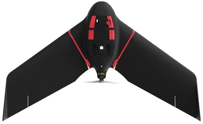
The eBee Ag drone, engineered by AgEagle Aerial Systems Inc.—a specialist in drone technology across multiple industries—is a fixed-wing drone and one of the best drones for agriculture in 2023. This drone is designed for farmers, agronomists, and agricultural service providers, providing a robust solution for efficient crop mapping and monitoring.
Equipped with a cutting-edge dual camera system, the eBee Ag drone provides superior precision mapping capabilities. Its high-resolution RGB sensor and four multispectral sensors work in harmony to capture detailed imagery of agricultural fields.
These images are then processed into accurate maps, aiding farmers in assessing crop health, identifying potential problem areas, and tracking growth over time.
With a substantial flight time of 55 minutes, it has the capacity to map approximately 160 hectares in just a single flight—a testament to its impressive operational capabilities.
In addition to its robust performance, the eBee Ag drone is compatible with all major farm management applications. This compatibility ensures its seamless integration with popular agricultural software systems, further enhancing its utility and efficiency in managing agricultural operations.
It is able to interface with a diverse array of agriculture software platforms. These include—but are not limited to—PIX4Dmapper, PIX4Dfields, Agisoft, Esri Drone2Map, DroneDeploy, and Trimble Ag Software. Such extensive compatibility offers farmers flexibility and choice, empowering them to select the software that aligns best with their specific operational needs and preferences.
3. DJI Phantom 4 Multispectral
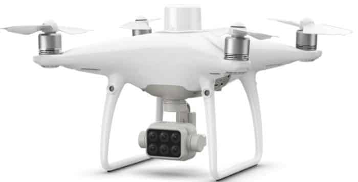
The DJI P4 Multispectral drone includes a high-resolution RGB camera along with a multispectral camera array with five sensors. These sensors capture the green, red, red-edge, and near-infrared bands of light, which can be processed into various vegetation indices, including NDVI and NDRE. The additional RGB sensor captures standard colour images.
The P4 Multispectral uses RTK for precise positioning and can get accuracy levels down to a centimetre. This RTK system uses a separate module with its own battery and can connect to an RTK network via a 4G dongle.
A standout feature of the P4 Multispectral is the TimeSync system. This innovative system synchronises the flight controller, camera, and RTK module, enhancing data accuracy and ensuring each photo uses the most precise metadata. This alignment optimises data collection and analysis, resulting in superior results for various applications.
The DJI P4 Multispectral drone is capable of a maximum flight time of approximately 27 minutes under optimal conditions. The drone’s transmission capabilities are facilitated by DJI’s advanced OcuSync technology, allowing a maximum transmission range of up to 7 kilometres.
4. WingtraOne VTOL Drone
The WingtraOne, designed by Swiss company Wingtra, is acknowledged as one of the best commercial drones and is great for mapping large areas of farmland.
It employs a Vertical Take-Off and Landing (VTOL) design, blending the benefits of both fixed-wing and multicopter drones. This innovative design allows it to take off and land in constrained spaces, making it incredibly adaptable to various environments.
A quality feature is its compatibility with various high-quality payloads, including the MicaSense RedEdge-P multispectral camera. This compatibility allows it to capture diverse spectral bands, significantly enhancing its utility for precision agriculture.
WingtraOne’s exceptional performance is evident in its flight time and coverage range. In optimal conditions, it can fly for up to 59 minutes and cover an impressive area of up to 766 acres. This capability makes it an excellent tool for mapping expansive farmland.
In terms of precision, the WingtraOne is equipped with a high-end PPK GNSS receiver, allowing it to achieve absolute accuracy down to 1 cm (0.4 in) without the need for any ground control points.
This superior level of accuracy further cements its position as a leading choice for agricultural applications.
The drone also includes the user-friendly WingtraPilot software for intuitive mission planning and flight control, making fully autonomous flight and data collection is a simple process. It’s durable design, and high-quality components ensure reliable operation across a range of conditions, making the WingtraOne is an ideal solution for the demands of agricultural drone usage.
4. eBee X
The eBee X drone, developed by Swiss drone manufacturer AgEagle Aerial Systems, is a high-precision fixed-wing drone renowned for mapping large areas. This versatile drone offers several features tailored to the needs of surveyors, GIS professionals, and researchers in various sectors, including agriculture.
One of its significant features is its extended flight time. Depending on the configuration and conditions, the eBee X can fly for up to 90 minutes on a single charge, covering an impressive area of up to 500 hectares at 120 meters altitude in one flight.
When equipped with RTK or PPK capabilities, the eBee X can reach absolute accuracy down to 3 cm without the need for ground control points, offering an even greater level of precision. This precision is complemented by the drone’s robust design, capable of withstanding challenging weather conditions and wind speeds up to 12 m/s.
Another notable feature of the eBee X is its compatibility with various payloads. Users can leverage the senseFly SODA 3D camera for 3D mapping, the senseFly Aeria X RGB camera for photogrammetry, and the MicaSense RedEdge-MX multispectral camera for agricultural and environmental monitoring, catering to a wide range of data capture needs.
Best Agriculture Drone For Spraying Fertiliser and Pesticides
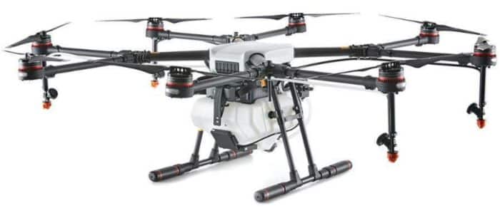
1. DJI Agras T20P
The DJI AGRAS T20P stands out as the best agriculture drone for spraying fertiliser and pesticides, owing to its multifaceted functionality and sophisticated design. This drone, besides being compact and lightweight, is engineered for high performance, offering substantial capacity for carrying payloads. Its ability to transport up to 20 kg of spraying payload and 35 L (25 kg) of spreading payload sets it apart in the agriculture drone market.
An integral component of the T20P is its Dual Atomised Spraying System that ensures precise and consistent spraying. This advanced feature is complemented by an array of multi-functional capabilities, including detailed surveying, accurate mapping, and effective spreading, facilitating a comprehensive solution for modern agricultural operations.
One of the T20P’s key features is the incorporation of Active Phased Array Radar and Binocular Vision. These technologies enhance obstacle detection and optimise flight planning, contributing to safe and efficient operations.
Another salient feature is its capability to perform mapping, spraying, and spreading simultaneously, bolstering its versatility. Additionally, it houses a UHD camera equipped with an adjustable gimbal, empowering real-time image capture and mapping.
Designed to resist tough conditions, the AGRAS T20P showcases superior reliability in complex farmland environments, making it an excellent choice for agriculturalists seeking efficiency and resilience.
2. DJI MG-1
 The DJI MG-1 is one of DJI’s older crop spraying drones but is still regarded as one of the best agriculture drones for spraying fertiliser and pesticides. With its advanced capabilities, this drone drastically improves the pace of agricultural operations, covering substantial areas up to 40-60 times quicker than manual spraying techniques.
In terms of durability, the MG-1 is outfitted with a sealed body and an optimised cooling system. This ensures the longevity of the motors, potentially tripling their lifespan. Moreover, the drone comes with wear-resistant, customisable spray nozzles, guaranteeing precise and comprehensive spray distribution.
A distinct characteristic of the MG-1 is its flexibility in operation. Offering three distinct flight modes – Smart, Manual Plus, and Manual – the drone facilitates planning and navigation for varying mission requirements. It also comes with an intelligent memory feature that records the drone’s coordinates, enabling the continuation of operations from the last recorded point after a battery change or tank refill.
The design of the MG-1 is centred around convenience and durability. It boasts a foldable Y-shaped design and a lightweight, robust carbon fibre airframe, facilitating easy installation and transport. Furthermore, the drone is equipped with a microwave radar and an intelligent flight control system, maintaining a constant height above crops for accurate spraying.
The MG-1’s dedicated remote controller is built with the Lightbridge 2 transmission system. It provides real-time flight data and low-latency controls housed in a dust-proof, water-resistant design.
3. Agricultural Drones On Alibaba: Uncover Value and Versatility
When exploring the vast landscape of crop-spraying drones, Alibaba serves as a veritable treasure trove of options. This expansive online marketplace houses an impressive spectrum of drone manufacturers focusing on industrial and agricultural applications, opening a gateway to various solutions tailored to your farming needs.
What sets Alibaba apart is the ability to discover an array of multifunctional agricultural drones that go beyond just crop spraying. These drones can handle tasks such as fertilising, pesticide application, and even mulch spreading, making them a versatile asset in modern farming.
What’s more, Alibaba’s platform introduces an opportunity to navigate a range of price points. Many of the agricultural drones found here are economically priced compared to their counterparts, like those from DJI. This cost-effectiveness does not compromise the drones’ efficiency or performance, ensuring affordability does not sacrifice quality.
Alibaba offers an array of choices and allows you to delve deeper into each product. Detailed specifications and manufacturer engagement give you a comprehensive understanding of the drone’s capabilities before making a decision.
How to Implement Drone Technology in Your Farming Operations
Investing in drone technology for agricultural practices requires thoughtful planning. The first major consideration is your budget. Drones come in a wide price range, depending on their features, camera quality, flight time, and data processing capabilities. It’s important to weigh these features against your budget constraints to make an informed decision.
Next, you should clearly define the purpose of the drone. Will it be used for monitoring crop health, irrigation systems, pest infestation, or livestock tracking? Your specific needs will determine which drone capabilities are crucial for your operation.
Lastly, the operation of agricultural drones may necessitate certain training or certification. Depending on local regulations, you may need to obtain a remote pilot certificate or equivalent. Training in flight operations and data interpretation is also important to maximise the utility of your drone.
Steps to Integrate Drones into Daily Operations
Integrating drone technology into daily farming operations can start by identifying tasks that can be optimised with aerial data, such as crop health monitoring, irrigation system checks, or soil analysis. Once these tasks are defined, the next step is to select an appropriate drone. It should fulfil your operational requirements and fit within your budget.
After the purchase, the drone’s successful implementation depends on either training the staff to operate it or hiring a professional drone operator. Regularly scheduled maintenance checks are also important to ensure the longevity and effectiveness of your drone.
Suggestions for Managing Data Collected by Drones
Drones can collect vast amounts of data quickly. This data, however, is only useful if it can be correctly interpreted and applied. Investing in agricultural software can help process and analyse drone data, transforming raw information into actionable insights. It is important to create a regular schedule for backing up data to prevent loss. Lastly, organise your data in a user-friendly format that makes it easy for your team to access and understand.
Top Drone Software For Agriculture
Pix4Dfields: Pix4Dfields software provides instant processing of imagery, powerful visualisation and analysis features, and easy export tools for seamless workflow integration. It offers detailed vegetation maps, zonation tools, and prescription maps, which can be very useful for precision agriculture. This is one of the most popular software for drone mapping.
Agisoft Metashape (formerly known as PhotoScan): Agisoft Metashape allows for photogrammetric processing of digital images and generates 3D spatial data used in GIS applications, cultural heritage documentation, and visual effects production. In agriculture, it can be used to create detailed orthomosaic maps and 3D models of fields for crop monitoring and analysis.
DroneDeploy: DroneDeploy is a cloud-based solution that turns aerial imagery into accurate, actionable data for farming. Its photogrammetry software can generate comprehensive 2D maps and 3D models, vegetation indices, terrain models, and zonal statistics.
DJI Terra: DJI Terra is a drone mapping software developed by DJI, which can transform drone data into digital 3D models and maps for easy analysis and decision-making. It enables the creation of realistic representations of a wide range of terrains, making it ideal for use in agriculture for tasks such as crop field mapping and analysis.
PrecisionMapper by PrecisionHawk: PrecisionMapper works by processing aerial data captured by drones into 2D and 3D outcomes. It’s used for generating orthomosaics, 3D meshes, vegetation index views (including NDVI, SAVI, etc.), and digital elevation models. These outputs can support decision-making in agriculture, from crop scouting to identifying areas of stress in fields.
Final Thoughts
The benefits of drones in agriculture are clear and impactful, ranging from precise crop monitoring and efficient resource management to cost reduction and yield improvement. As the technology continues to evolve and become more accessible, the adoption of drones in agriculture is expected to increase significantly. For farmers, embracing drone technology not only represents an investment in their operations but also in the sustainable future of agriculture.
Am interested in crop spraying drones,where do I buy one ?
Hi Minhaj,
Do you know companies that could provide services to take radar pictures with drones? I am looking on the internet, but I could not find anyone with drones and cameras with Radar. I want to evaluate the possibility of estimating the water content of the soil profile, using Radar images.
Hi Diana
Sorry, I could not find any company that provides the service you are looking for, would you be willing to look at an alternative to RADAR? there are drones that come equipped with LiDAR sensors, which can capture the type of data you are looking for. There are companies in the USA and Europe that provide drone surveys with LiDAR sensors.
All the best
Minhaj
Hi, I’m looking to include Drones in my Secondary Geography Curriculum. What kind of Camera/Filter etc would I need to survey an agricultural field?
I think this might be a do-able project for my students.
I was also wondering about surveying river beds but think this might involve very expensive LIDAR equipment.
What are your thoughts?
Pete.
Hi Pete
The best drones for agricultural use are ones that either come with a multispectral camera or can be fitted with one, however, it really depends on what kind of data you are looking to capture. A drone like the Phantom 4 Pro which comes with a 20MP RGB camera can provide you with high-quality maps, or if you want even more data, like data for crop and soil health, a drone with a multispectral camera like the DJI Phantom 4 Multispectral will be more suitable.
The same applies to surveying river beds, a drone with a high-quality RGB camera will usually do, but a drone with a multispectral camera will provide even more data. As you are an educator, you may be eligible for DJI’s education discount, if you do decide to purchase a DJI drone, it will be best to contact them and let them know how you will be using their drones and ask them if you are eligible for an education discount.
All the best
Minhaj