
Drones are an amazing piece of equipment, not only are they fun to fly but with technological advancements, drones are now being more widely used in the commercial sector. One area where they are being utilised more and more is in photogrammetry. Drones for photogrammetry are being used in a variety of industries to create detailed maps and 3D models.
There are a lot of drones that are suitable for photogrammetry, some have been engineered for this specific purpose, whilst most are capable because they come with high-end cameras, GPS modules and autonomous flying modes.
Whether you are a professional drone pilot looking at ways to generate revenue or a business owner looking to utilise the power of drones through photogrammetry, this article will explore what drone photogrammetry is and how it is being used in different industries.
What Is Drone Photogrammetry?
So, in simple terms, photogrammetry is the science of recording measurements of physical objects and areas of land through the use of photography.
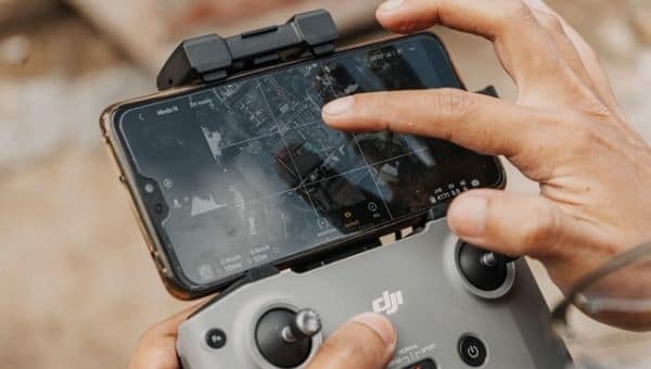
Drone photogrammetry involves taking high-resolution photographs of an area from different angles and altitudes. These images are then processed using specialised software to create 2D maps and 3D models of the area.
The more images you can capture with at least a 70-80% overlap, the more accurate your data will be. To get the best and most accurate data, you will need a GPS-enabled drone that has autonomous flight technology and a high-resolution camera. All images that are captured will be embedded with the drone’s GPS data which will help in creating accurate maps and 3D models.
Traditional methods of photogrammetry is a long and expensive process and even sometimes a health hazard, especially if you have to map a dangerous terrain. However, with the help of high-end drones, what used to take a week via rovers and land scanners can now be completed much faster and more safely.
As most advanced drones now come equipped with professional-grade cameras like those from DJI and Autel Robotics, you can easily capture high-resolution images at low-altitude that will provide better data for the creation of 2D maps and 3D models.
Drones for photogrammetry can be used in a variety of industries, such as construction, agriculture, aggregates, and environmental monitoring. It can be used to create accurate maps of large areas, monitor the progress of construction projects, analyse crop health, and survey areas that are difficult to access. The use of drones in photogrammetry has made the process faster, more accurate, and less expensive than traditional methods.
Is Drone Photogrammetry Accurate?
With the right equipment and processing software, drone photogrammetry can achieve sub-centimetre-level accuracy.
It’s worth noting that the accuracy of drone photogrammetry can be affected by external factors such as weather conditions, GPS signal quality, and obstacles in the environment. Therefore, it’s important to consider these factors when planning a project and to take steps to minimise their impact on the accuracy of the data.
Overall, drone photogrammetry has proven to be a highly accurate and efficient method for mapping and surveying large areas, and it has revolutionised the way we collect and analyse spatial data.
For an independent analysis of how accurate drone photogrammetry is, read this article from Canadian Science Publishing.
Drones For Photogrammetry – Multicopter or Fixed Wing?
So, when it comes to choosing a drone for photogrammetry, you have a lot of choices, and the first thing you will want to decide on is whether you want a multi-copter drone or one with a fixed wing.
Both of the advantages and disadvantages and which one you choose well to come down to a number of factors like the size of your project, what data needs to be captured, your budget and your overall skill level in piloting a drone.
As multi-copters are the more popular type of drone, there are a lot more options in this category, and they come in a range of prices and are cheaper than fixed-wing drones. Multi-copter drones usually have four rotors, but there are ones that come with 6-8 rotors, these drones vary in size and weight, but they are relatively easy to fly.
Some popular multi-copter drone brands include DJI (obviously), Yuneec, Autel and Parrot. DJI has a number of drones that are suitable for photogrammetry, while the rest have 1-3.
Multi-copters excel in manoeuvrability, as they take off and land vertically, so they don’t need a lot of space when taking flight. They also hover very accurately and can be easily manoeuvred up or down and orbit around a point of interest with little difficulty, this makes them great for surveying and 3D modelling.
Another area where multi-copters may be more useful is their capacity to carry a higher payload. This is an advantageous feature that fixed-wing drones are not capable of and will come in handy if you need to attach heavy or multiple onto the drone.
One area where multi-copters were deemed a little behind fixed-wing drones is their overall flight time; however, this is being improved with better design and technological advancements. For example, the DJI Matrice 300 RTK has a flight time of 55 minutes, which is as good as any fixed-wing drone.
However, for the most part, multi-copters have a shorter flight time, and so if your project requires a drone that can stay up for a long time, they may not be the most cost-efficient option as many flight runs will be required to complete the mission properly. Another area where they fall short is overall coverage, although this is also being improved as a lot of high-end multi-copters come with better batteries for increased coverage.
As for fixed-wing drones, these are expensive drones when compared to their multi-copter counterparts and harder to operate, so flying one will require a bit more training. Unlike multi-copter drones, there are not many fixed-wing drones that are suitable for photogrammetry.
Those that have been manufactured for commercial purposes are more than capable of capturing data for maps and 3D models. Their long flight times are one of the reasons they are preferred for large projects, and their design allows them to be operated in windy conditions.
There are a couple of hybrid fixed-wing drones that bring the versatility of a multi-copter and retain the robustness and power of a traditional fixed-wing drone.
These are called vertical take-off and landing (VTOL) drones and come with similar features to that of a multi-copter drone.
Best Drones For Photogrammetry
While there are a lot of drones that are capable of producing accurate data for detailed maps and 3D models. There are a few that stand out from the rest, and this is because they have been designed for commercial use.
When looking to invest in drones for the purpose of photogrammetry, there are a few features that you should look out for, and one of the most important is the camera.
The camera needs to have a high resolution, preferably one that comes with a sensor that can capture 20MP images or better, although something above 12MP will do. The higher the pixel rate, the more accurate the image will be when it comes to calculating ground sampling data (GSD).
GSD is basically a pixel-level representation of real-world measurements in an image, the lower the GSD is, the more accurate the data will be. For example, if you want an image to represent 5cm GSD, this means that every pixel in that image will be equal to 5cm in real life.
So, if a drone comes with a camera that has a high resolution and a large sensor, this will allow it to capture more image data in every shot, which will result in better accuracy for maps and surveys.
To find out more about GSD and its importance for drone mapping and surveying, read this excellent article from Aero Propeller.
Something else to take into consideration about cameras is whether to get one with an electronic shutter or a mechanical shutter. Drones with an electronic shutter may result in motion blur or a rolling shutter effect, this distorts the images and makes it harder for photogrammetry software to accurately stitch the images together.
The better option would be to purchase a drone that has a mechanical shutter because it will not cause these types of distortion and result in better image quality.
You may want to consider purchasing a drone that is compatible with different types of cameras, this is especially important if you are a drone service provider and do not want to limit your services to just one industry.
Most drones come with the standard RGB camera, which is good enough for most photogrammetry purposes. However, if you are in an industry like agriculture, you will need a multi-spectral or near-infrared (NIR) camera to analyse the overall health of your crops from multiple imaging solutions.
For other industries like energy or construction, a thermal imaging camera will come in handy to help identify and analyse abnormal heat signatures.
Another important feature to consider is the drone’s overall flight time, if you are going to be surveying or mapping a large area, you will want a drone that has a long flight time to help you complete the project without having to make too many flights.
One final thing to note is in relation to GPS accuracy, all drones come with a standard GPS module that is useful for everyday needs as it will pinpoint location data within a certain range of your target. However, for mapping and surveying purposes, the location data that will be embedded in the images from a drone’s GPS module will not be sufficient.
Therefore, to get the most accurate location data for maps and surveys, drone professionals use a combination of GCPSs (ground control points) and GPS correctional technology like RTK (real-time kinematic and PPK (post-processing kinematic) for centimetre-level accuracy.
A lot of drones now come with RTK technology, and although they are expensive, it is the best option if you want to produce accurate maps, surveys and 3D models.
To find out more about these GPS correctional technology, read this helpful guide from Aero Propeller.
All of the drones I have listed below come with the features I have mentioned above.
They all have an RTK system, a camera with a 20MP+ sensor, and a flight time of 30 minutes or above and some of the drones are compatible with different types of cameras.
Best Multicopter Drones for Photogrammetry
1. DJI Phantom 4 RTK
The DJI Phantom 4 RTK is a top-of-the-line drone that has been specifically designed for surveying and mapping. It features a high-precision RTK module, which provides enhanced GPS accuracy, making it ideal for use in applications that require high levels of precision. The drone also comes equipped with a 20-megapixel camera that has a 1-inch sensor, allowing it to capture highly detailed images. It has a flight time of up to 30 minutes, which makes it suitable for covering large areas in a single flight. The DJI Phantom 4 RTK is easy to operate and comes with a variety of safety features that ensure a smooth and secure flight. The DJI Phantom 4 RTK is a popular choice for anyone looking for a reliable and accurate drone for photogrammetry.
2. DJI Matrice 300 RTK
The DJI Matrice 300 RTK is a high-performance drone designed for commercial applications, including mapping, inspection, and search and rescue operations. It features a robust and modular design, which allows it to carry multiple payloads and sensors simultaneously. The drone has a maximum flight time of up to 55 minutes and can fly at a maximum speed of 51 mph. The DJI Matrice 300 RTK also comes equipped with advanced safety features, including obstacle avoidance sensors, multiple redundancy systems and a return-to-home function. It has a high-precision RTK module, which provides accurate positioning data, and it comes with an IP45 rating making it waterproof and which allows it to be operated in harsh weather conditions. Overall, the DJI Matrice 300 RTK is a fantastic choice for anyone looking for a powerful and versatile drone for photogrammetry and other commercial applications.
3. DJI Mavic 3E
The DJI Mavic 3E is an enterprise-level drone that is packed with features designed to make it an ideal choice for a wide range of applications. It comes with a 20-megapixel 4/3 CMOS sensor with a mechanical shutter, which allows it to capture high-quality images even in challenging lighting conditions. Additionally, the drone features a second zoom camera with 56x hybrid zoom, providing an even greater level of flexibility in the types of shots that can be captured. The drone has obstacle avoidance sensors to help prevent accidents during flight and features intelligent flight modes that enable it to autonomously navigate around obstacles and capture stunning footage. With a flight time of up to 45 minutes and a transmission range of up to 15km, the DJI Mavic 3E is a powerful and versatile drone that can handle even the most challenging missions.
4. DJI Mavic 3M
The DJI Mavic 3M is a powerful and versatile drone that has been specifically designed for agricultural and environmental use. With a dual-camera system consisting of a 4/3 CMOS wide camera and a 4-band multispectral camera, each with a 5MP image sensor, the drone is able to capture high-quality data that can be used for crop mapping, plant counting, and other applications. The DJI Mavic 3M has a flight time of up to 43 minutes, allowing it to cover up to 200 hectares in a single flight. The drone also features RTK technology, which provides highly accurate positioning data, making it well-suited for use in applications that require a high degree of precision. Additionally, the drone comes equipped with omnidirectional obstacle avoidance sensors and an advanced return-to-home feature. Overall, the DJI Mavic 3M is a powerful drone for agricultural and environmental use.
5. DJI M30T
The DJI M30T is a highly capable drone that has been designed for use in commercial and industrial applications. It features a high-quality multisensor payload that includes a high-resolution RGB and thermal imaging camera and a laser range finder. Additionally, the drone features a night vision FPV camera that will enhance its night flying capabilities. The DJI M30T also has a range of safety features, including obstacle avoidance sensors, multiple redundancy modules and an ADS-B receiver. The drone has a flight time of up to 41 minutes and a transmission range of 15km, making it well-suited for covering large areas in a single flight. It also features a range of intelligent flight modes, has a top speed of 51 mph and has an IP55 rating which makes it one of the best waterproof drones on the market.
Best Fixed-wing Drones For Photogrammetry
1. WingtraOne
This is probably the best overall drone for photogrammetry, it’s a hybrid drone that combines the best features of a multicopter and a fixed-wing drone. The WingtraOne drone is known as vertical take-off, and landing drone or VTOL and this feature are what makes it more flexible and better than a traditional fixed-wing drone. It’s a drone that is suitable for projects that need large areas to be mapped or surveyed, and thanks to its inbuilt PPK GNSS receiver and the Sony RXR1 2 camera, it can deliver 1cm level accuracy. It has a maximum flight time of 59 minutes and is compatible with multiple cameras, including 3 professional Sony RGB cameras and two multispectral cameras.
2. SenseFly eBee X
This is a large fixed-wing drone that has a robust build and is compatible with multiple payloads. It has an average flight time of 60 minutes and has the capability to fly for 90 minutes, subject to payload and battery. It comes with an in-built PPK/RTK module for centimetre-level accuracy; this feature will reduce the need for multiple GCPs. It has a wide range of interchangeable cameras, from the high-quality 24MP Aeria X with APS-C sensor to the MicaSense RedEdge multispectral camera and SenseFly 3D mapping camera. It has a wind resistance of 28 mph, can be flown in light rain and has a range of 8km.
3. Atmos Marlyn
The Atmos Marlyn drone is a highly specialised drone designed specifically for surveying and mapping applications. Its modular design allows it to be easily configured with a wide range of sensors, including RGB, thermal, and multispectral cameras. The drone has a flight time of 50 minutes and can cover up to 320 ha in a single flight. Additionally, the Atmos Marlyn features a PPK module, which provides highly accurate positioning data, making it well-suited for use in applications requiring high-precision geospatial data.
Drone Photogrammetry Software
A good drone is just one part of aerial photogrammetry, the other is having access to good photogrammetry software that will allow you to manipulate the data you capture into highly detailed 2D/3D maps and 3D models.
The power of drone photogrammetry is being utilised in many industries like construction, mining, agriculture and many others to help them acquire accurate data faster that will allow them to make better-informed decisions when it comes to planning and executing a project.
Fortunately, there is a lot of very good photogrammetry software that is compatible with a wide range of high-end drones. Some of the more popular photogrammetry software for drones include PIX4D, DroneDeploy, AeroPropeller, PrecisionHawk, Site Scan, Maps Made Easy, Agisoft, DJI Terra, Mapware, and many others.
Check out this list of the best drone mapping software for more options.
Industries Using Drones For Photogrammetry
According to Business Insider, the drone service market is set to be worth around $63 billion by the year 2025, and some of the biggest industries to benefit from technology especially in the area of photogrammetry, are the following:
Mining & Quarries – Mining is one of the most hazardous places to work, however, with the use of drones, you can map and survey sites without putting anyone in danger. Data collected from drones will help companies acquire accurate stockpile inventory which should help overall ROI. As drones are easy to deploy, mining sites can be mapped and surveyed frequently which will allow you to compare data and make more informed decisions when it comes to mining operations.
Agriculture – The agriculture industry is one of the biggest beneficiaries of drone technology, with the aid of drone maps and surveys, farmers can monitor their crops frequently and more efficiently. This will allow them to identify any issues with regards to the health of their crops act upon this data faster. Regular crop analysis can help mitigate the spread of disease, find areas that are not being irrigated properly, identify areas that should be treated with herbicide/pesticide and monitor crop growth.
Construction & Engineering – From the early process of bidding for contracts to planning and implementing construction projects, drones are providing a competitive edge for companies who are investing in this technology. With the aid of drones, contractors can map and survey construction sites in a quick and efficient manner without compromising on data accuracy. Drone maps and surveys also allow you to track the progress of a project frequently and without having to travel to the site. With the aid of 3D maps, you can compare what the initial design looked like to the one that is being built and make sure that they are the same. One of the biggest benefits is of course, safety, drones allow you to map and survey a site without the need for traditional surveying equipment, which is safer and less time-consuming.
Environmental monitoring – Drones are starting to play a huge role in the way we monitor our environment to fight pollution and climate change and help protect wildlife and the planet. There are many areas where drone-produced maps and surveys can help the environment and wildlife. With the aid of these detailed maps, engineers can better understand how to reduce the impact of things like glacial flooding, wildfires and air pollution.
Photogrammetry vs LIDAR
This subject needs its own whole article and there is no straight forward answer as to which method is better. The technology has been around for a few decades; however, it is only recently that LiDAR systems have been made compact enough for a drone to carry around.
LiDAR stands for light detection and ranging and is similar to how SONAR and RADAR works. It works by firing laser pulses from a sensor onto the ground and then calculating how long it takes for the pulse to reflect back to the sensor. LiDAR systems need a GNSS module and IMU to calculate the exact position these laser pulses are reflected from and then with the help of 3D software, these georeferenced data can be turned into a detailed 3D cloud point. These 3D cloud points will provide a detailed visual representation of the area or object that has been scanned.
One of the main advantages of using LiDAR is its accuracy both in absolute and relative terms, this allows you to know exactly where in the world each data point is located and how they relate to each other in terms of distance.
One of the big advantages of a LiDAR system is that the laser pulses can penetrate areas of land that are covered by dense vegetation. The laser doesn’t actually go through anything but finds gaps between leaves and branches and can get an accurate representation of the terrain below.
LiDAR is also the better choice for mapping and surveying if you are required to or can only work at night. As LiDAR uses laser pulses to scan and map an area or object, it does not require light to do this, which contrasts with photogrammetry, which is only good for daytime.
One of the biggest issues with LiDAR is the associated costs that come with investing in the technology. You may end up spending hundreds of thousands of pounds on just the equipment and software plus additional cost for training people to use and interpret LiDAR data.
Both LiDAR and photogrammetry have their strengths and weaknesses, and which method is suitable you choose will depend upon many factors, including what the project is, the type of data you require and ultimately, your budget.
For a more comprehensive and balanced view of these two mapping and surveying methods, read this article from geoawesomeness.com
Final Thoughts
Drones provide a new and accessible way to map and survey areas and objects without the added costs of traditional land-based methods. With aid of RTK/PPK technology, accuracy is not compromised, and the health risk to personnel is greatly reduced, especially in areas that are deemed hazardous to access by land.